Hier ein OpenStreetMap - WMS
Habs angepasst... und jeweils (31467 und 4326) verprobt, danke an Pfeffer:
# de_top SM.wms - Version 0.2
TakenFromUrl: http://www.wheregroup.com/de/freier_wms_mit_openstreetmap_daten
GetCapabilitiesUrl: http://osm.wheregroup.com/cgi-bin/mapserv?map=/data/umn/osm/osm_basic.map&REQUEST=GetCapabilities&SERVICE=WMS&VERSION=1.1.1
Name: OpenStreetMap
MainUrl: http://osm.wheregroup.com/cgi-bin/osm_basic.xml?
MapType: topo
ServiceTypeUrlPart: SERVICE=WMS
VersionUrlPart: VERSION=1.1.1
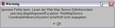
CoordinateReferenceSystemCacheWolf: 31467 4326
CoordinateReferenceSystemUrlPart: SRS=EPSG:31467 SRS=EPSG:4326
RequestUrlPart: REQUEST=GetMap
LayersUrlPart: LAYERS=Landwirtschaft,Industriegebiet,Bauland,Gruenflaeche,unkultiviertes_Land,Park,Naherholungsgebiet,Wald,Wiese,Wasser,Fluesse,Baeche,Kanal,Insel,Kueste,Strand,Fussgaengerzone,Fussgaengerweg,Radweg,Wege,Wohnstrasse,Zufahrtswege,einfache_Strasse,Landstrasse,Bundesstrasse,Kraftfahrstrasse,Autobahn,Ortschaft,Weiler,Dorf,Stadt,Grossstadt,Bahn,Bahnhof,Gebaeude
StylesUrlPart: STYLES=
ImageFormatUrlPart: FORMAT=image/png
BoundingBoxTopLeftWGS84: N 55.0960681 E 6.07358734
BoundingBoxButtomRightWGS84: N 47.161701 E 16.05521058
MinScale: 0.6
MaxScale: 99.99
RecommendedScale: 1
ImageFileExtension: .png
Habs angepasst... und jeweils (31467 und 4326) verprobt, danke an Pfeffer:
# de_top
SM.wms - Version 0.2TakenFromUrl: http://www.wheregroup.com/de/freier_wms_mit_openstreetmap_daten
GetCapabilitiesUrl: http://osm.wheregroup.com/cgi-bin/mapserv?map=/data/umn/osm/osm_basic.map&REQUEST=GetCapabilities&SERVICE=WMS&VERSION=1.1.1
Name: OpenStreetMap
MainUrl: http://osm.wheregroup.com/cgi-bin/osm_basic.xml?
MapType: topo
ServiceTypeUrlPart: SERVICE=WMS
VersionUrlPart: VERSION=1.1.1
CoordinateReferenceSystemCacheWolf: 31467 4326
CoordinateReferenceSystemUrlPart: SRS=EPSG:31467 SRS=EPSG:4326
RequestUrlPart: REQUEST=GetMap
LayersUrlPart: LAYERS=Landwirtschaft,Industriegebiet,Bauland,Gruenflaeche,unkultiviertes_Land,Park,Naherholungsgebiet,Wald,Wiese,Wasser,Fluesse,Baeche,Kanal,Insel,Kueste,Strand,Fussgaengerzone,Fussgaengerweg,Radweg,Wege,Wohnstrasse,Zufahrtswege,einfache_Strasse,Landstrasse,Bundesstrasse,Kraftfahrstrasse,Autobahn,Ortschaft,Weiler,Dorf,Stadt,Grossstadt,Bahn,Bahnhof,Gebaeude
StylesUrlPart: STYLES=
ImageFormatUrlPart: FORMAT=image/png
BoundingBoxTopLeftWGS84: N 55.0960681 E 6.07358734
BoundingBoxButtomRightWGS84: N 47.161701 E 16.05521058
MinScale: 0.6
MaxScale: 99.99
RecommendedScale: 1
ImageFileExtension: .png